|
|
CONCEPTS, TECHNOLOGIES, SYSTEMS AND USERS OF THE NEXT GEOSS March 24-26, 2015, Norfolk, VA, USA |
|
WORKSHOP SCOPE AND OBJECTIVESThe on-going evolution in the modus operandi of doing research and organizing science is largely driven by the many technological and information revolutions that characterizing the present digital era. Earth system scientists need to use and integrate very heterogeneous data and information characterizing various fields of academic study to understand the Earth as a system. Besides data diversity, data volume is dramatically increasing due the new and powerful technologies made available to acquire and share data and information. Advanced remote sensing technologies brought the challenge of data deluge for satellite data analysis and interpretation. Drones encapsulate the logic of (low cost) distributed, ubiquitous monitoring information capture. The convergence of wireless technologies, micro-electromechanical systems and the Internet is providing objects, animals and people with the ability to transfer data over a network without requiring human-to-human or human-to-computer interaction. The open data revolution is increasingly affecting also digital models and processing algorithms made more and more accessible and interoperable on Internet. GEOSS Users (and their Web applications) need to know more about how to effectively discover and use this huge amount of heterogeneous data and the increasing number of processing services and digital models. There exists a clear need to define information in terms of data, knowledge in terms of information, and decision-support (i.e. wisdom) in terms of knowledge: the DIKW paradigm. The 4th GEOSS S&T Stakeholder Workshop focused on the scope of the future GEOSS and the concepts and technologies that can support a future-oriented “system of systems” providing observations and practice-relevant knowledge to a wide range of users. Information and knowledge systems are challenged by rapidly developing knowledge needs on the one side and an equally rapid development in (big) data availability not only from traditional sensors but also from a variety of human sensors, the developing Internet of Things (IoT) and Internet of Everything (IoE) scenarios, and the output of increasingly more advanced models. Cloud computing provides any public and private organization with the ability to use data and applications over the Internet instead of hosting, storing, or processing them on locally managed hardware. In such a fast moving technological and information environment, GEOSS (and in particular its common infrastructure and information system) must be flexible to leverage a never-ending technological revolution. To reinforce GEOSS role and use, anticipating the next revolution is important. GEOSS (and in particular its common infrastructure and information system) should apply the DIKW patterns and create knowledge; this requires an innovative sustainability and economic paradigm. Public-private-partnerships (PPP) may be considered for that. Outcomes of the workshop include position papers on various aspects of the future GEOSS, including: the integration of different sensor networks, the handling of the emerging “data super nova”, data patterns recognition to generate information, and principles recognition to generate knowledge. Participants in the workshop included technology developers; experts in data management, integration, and analysis; developers of knowledge systems and concepts for the linkage between decision making and knowledge; and user representatives. GEO and GEOSSThe Group on Earth Observations (GEO) is implemented the Global Earth Observation System of Systems (GEOSS) with the goal to improve access to, and the use of, Earth observations for a broad range of stakeholders. The 10 Year Implementation Plan for GEOSS endorsed by a Ministerial Summit in 2005 states “GEOSS is a step toward addressing the challenges articulated by United Nations Millennium Declaration and the 2002 World Summit on Sustainable Development, including the achievement of the Millennium Development Goals. GEOSS will also further the implementation of international environmental treaty obligations.” The recent Ministerial Summit on Earth Observation held in January 2014 in Geneva underlined the importance of the SGDs and of GEO focusing the development of GEOSS on the information needs that arise from humanity's quest for the SGDs. The Implementation Plan Working Group (IPWG) initiated during the Ministerial Summit in 2014 with the mandate to draft the next 10 Year Implementation Plan for GEOSS provided in March 2015 a first report summarizing the first “reflective phase” of the IPWG and laying out the scheme for the further development of GEOSS. They also presented a Draft Strategic Plan to the GEO PLenary in November 2014. The GSTS Workshops built on these documents and discuss the science and metric needed to achieve the goals indicated in the documents. OUTPUT
SESSION OVERVIEWThe program includes plenary session that will feature invited high-level presentations to introduce core themes. Subsequent breakout sessions will focus on sub-themes and consist of short presentations, panels, and discussions. After each breakout sessions, a plenary session will summarize the outcomes of the breakout sessions and provide input for subsequent sessions. The following sessions are proposed:
SESSION DETAILSJoint Plenary Session A: Changing Science for a Changing Planet Co-Chair: Hans-Peter Plag, James Syvitski The rapid changes in key variables of the planet (for example, biodiversity, atmospheric chemistry, ocean heat content, water cycle and sediment transport, ocean acidity, land cover, ice sheets, sea level) that are already taking place and expected to increase can lead to severe challenges for humanity. We need to ask whether the current approach to science will be able to identify these challenges in a timely manner and provide the practice-relevant knowledge needed to address the challenges or whether a new approach to rapid knowledge creation is needed. Joint Breakout Sessions: Creating the practice-relevant knowledge to cope with global change The breakout sessions reviewed methods for knowledge creation related to key areas of global change and consider the possibilities of rapid changes that might challenge the traditional scientific approach. Joint Breakout Session 1: Intelligent use of data quantity vs focusing on data quality Chair: Stefano Nativi; Rapporteur: Bart de Lathouwer The new Web 2.0 environment has impacted economy with what is termed "wikinomics" by Don Tapscott and Anthony Williams and shifted the basis to four principles: openness, peering, sharing and acting globally. How is the Web 2.0 impacting the generation and use of data and knowledge? How can, and how should, classical Earth observation with a focus on data quality make use of the new technologies where the data quantity provides for new ways of extracting information and knowledge from the huge amount of data available now? How can new approaches of co-design of research agendas for problem solutions and co-creation of knowledge help make use of data quantity? Joint Breakout Session 2: Shifting from disciplinary to problem and solution focused science Chair: Kathy Fontaine; Rapporteur: Andiswa Mlisa The complexity of global change, climate change, and sustainability requires a transition from a bottom-up, discipline-based approach that often addresses complexity by simplification, to a top-down approach starting at the problem and recognizing the full scale of complexity. How can observation be used to provide the constraints and evidence for such an problem and solution-oriented approach? Joint Breakout Session 3: Avoiding Type II errors Chair: Hans-Peter Plag Current global and climate change science and science relevant to societal sustainability science is focused more on avoiding Type I errors, that is, "false positives" (false alarms), than avoiding Tyoe II erros, that is, "false negatives" (missed alarms). The session will look at whether focusing on Type I errors will allow us to identify and avoid severe thresholds (like crossing the global boundaries of the safe operating space for humanity) before it is too late. The threshold discussion used by, e.g., Tim Lenton and Jim White, raises the question whether it would be better to focus also on Type II errors. Is the transition out of the Holocene a time where Type II errors are more critical, and if so, how would a science look like and be organized if the main emphasis is on avoiding Type II errors? How would that impact the relevance of observations and the prioritizing of observation systems? Joint Plenary Session B: Linking Societal Goals, Science, Metrics, and Observation Systems Co-Chairs: Stefano Nativi, Hans-Peter Plag In this second joint session, the aim was to bring together science and goal-based metrics in order to better understand the requirements on future observing systems that provide the data required to quantify the metrics and enable applications with societal benefits. Plenary Session 1: Leveraging a Never Ending Technological Revolution for the next GEOSS Chair: Michel Schouppe The technological revolutions are happening at an increasing speed and we can expect to soon see a more or less never ending revolution. Concepts are increasingly outdated before they can be validated and implemented. This requires a new approach anticipating what technologies might be available in the future and building this into conceptual developments from the start. Breakout Sessions Block 1: Emerging revolutions: challenges and opportunities for GEOSS The breakout sessions in this block looked at several anticipated revolutions and the impacts these might have in general on the way Earth observations are being conducted, and more specifically, on how the next GEOSS should be designed and implemented. Breakout Session 1.1: Cloud and Big Data Revolutions Co-Chairs: Lorenzo Bigagli; Rapporteur: Bob Chen This session focused on both the origin of big data, including that coming from new technologies such a drones, microsensors, sensor nets, the IoT and IoP (including citizen observatories and social media), and the handling of big data. Questions to be considering included how open data can be utilized as an as an engine for innovation, and how e-Infrastructures for e-Science can facilitated the use of big data at a larger scale. An important question is ownership of personal information that might become available through the integration of the IoT and the Internet of People (IoP). Breakout Session 1.2: Secure Consumerization: the Genuine Trustworthiness Revolution Co-Chairs: Craig Lee; Rapporteur: Paolo Mazzetti The cloud is the natural environment for consumerized (i.e. Bring your own device -BYOD and bring your own app -BYOA) deployment. For many applications it is the only environment that permits realistic testing. Community productivity will increase by following enterprise device consumerization trends. However, security is getting a more and more important challenge. An important question is how to protect sensitive information for all user activities on all devices using all applications." Security is a key factor to grow a Genuine Trustworthiness among scientists and enable virtual research environments and collaborative researches. Breakout Session 1.3: Social Revolution: Crowdsourcing Movement and Earth Observation Co-Chairs: Michel Schouppe; Rapporteur: Stefano Nativi Crowd sourcing can provide more and new data, and it can help to improve data quality. New sensors might support crowd sourcing, for example for observations related to pollution or other environmental parameters. New boards such as Intel's GALILEO and Arduino allow for citizen scientists to contribute to observatons. Citizens' science and virtual research communities open opportunities for new partnerships to build shared knowledge at the global scale. Private-Public-Partnerships (PPPs) also can help to increase data availablity and the sharing of data and knowledge. Measurements of opportunity might become available from the Internet of Things, the Internet of People, and the Internet of Models. Plenary Session 2: From Data to Knowledge Sharing Chair: Greg Yetman Based on the previous plenary and breakout sessions, the session discussed the transition from open data to open knowledge and ways that can facilitate the sharing of knowledge. Of particular interested was the role of GEO in facilitating knowledge sharing and the approach to GEOSS as a knowledge sharing utility. Plenary Session 3: Creating knowledge by applying a new sustainability and economic paradigm Chair: Douglas Cripe Changes are not only in science and technology but also in society in terms of creation of knowlegde, access to knowledge, use of knowledge, and value of knowledge. How can GEOSS both make use of these changes and integrate into a changing knowledge landscape? The use of crowd sourcing and citizen scientists, for example, provides new economic opportunities for data collection. Globally available cyber infrastructure changes access to information and opens novel ways for the creation of new knowledge. What new economic avenues are developing to sustain public observing systems and information infrastructure? Which kind of public-private partnership (PPP) can be developed for sustained global observations? These are some of the questions the session addressed. Breakout Sessions Block 2: Sustaining GEOSS in a Changing World In this breakout session block, new paths to a sustained earth observing system of systems capable of providing solution-focused and practice relevant information was discussed. Sustaining regional networks, inlcuding those in the developing world is of particular interest. Building capacity both in the collection of the observations and in the use of the data to create the practice-relevant knowledge is another cornerstone. Finally having information systems that provide to users what they need to address societal challenges is crucial to utilize the benefits of earth observations. Breakout Session 2.1: Global and Regional Observation Networks Sustainability and Capacity Building Co-Chairs: Senay Habtezion, Bob Chen, Rapporteur: Wolfgang Graps The session focused on the costing of measurement and monitoring and the value of investing in both new measurements where needed and in making existing measurements useful for assessing targets. The economic aspect of sustaining observation networks and services is essential, and having an idea of the investment and operating costs of monitoring systems is essential to help make monitoring a stainable exercise by itself. An example of a cost assessment is an effort made by GCOS, see http://www.wmo.int/pages/prog/gcos/Publications/gcos-138.pdf. On top of the costs of measurement and monitoring, the session explicitly addressed the "economic value" of measurement and monitoring for the application/decision being addressed. In the decision on a more extensive use of measurement and monitoring in decision making processes at all levels, The economic value is one of the key factors being considered, as well as other kinds of benefits. An effort is undertaken with the Sustainable Development Solutions Network (SDSN) to pull together some ballpark estimates as a potential input to the June 2015 development financing meeting. The outcome of the breakout session and the overall workshop could be quite helpful for this process. While it is nice to have a forward look at new emerging technologies, in this session, it was consider what can be reasonably put into practice in order to implement a "GEOSS for all". In particular, this effort should consider needs of the developing countries or countries that might lag behind in terms of technological take-up. Breakout Session 2.2: A Sustainable GEO Information System of Systems Chair: Stefano Nativi, Rapporteur: Greg Yetman New governance and resourcing mechanisms is another challenging dimension for knowledge creation, (also considering the many initiatives underplay). "Reproducible science" and "multi-disciplinary knowledge creation to address complexity" are important subjects of a more cross-cutting nature which was addressed in this breakout session. The session explored how these governance and resourcing mechanisms can help to improve applicability, reproducability, traceability, and usability of data, information and knowledge. The linkage between governance and users, for example, through advanced user feedback on data and service quality and applicability, will also be addressed. References: See http://radar.oreilly.com/2013/01/open-data-business-models-deloitte-insight.html; http://www.nature.com/nature/focus/accessdebate/34.html. Plenary Session4: Final Discussion and Conclusions: Setting Priorities Co-Chairs: Hans Peter Plag, Stefano Nativi Based on the previous sessions, priorities for Earth observations were discussed and translated into recommendations. PROGRAM AND SCHEDULEPROGRAMFor room information, see the Schedule. Tuesday, March 24, 2015
Wednesday, March 25, 2015
Thursday, March 26, 2015
SCHEDULEOverview Week March 23-27, 2015
ABSTRACTSData Citation: DOI-Enabling GEOSS Discovery and Access David Arctur (University of Texas at Austin), Robert Arko (Lamont-Doherty Earth Observatory), Stefano Nativi (CNR, ESSI Lab), Joan Starr (California Digital Library) Data citation is enabling much more than just discovery of published resources; it is enabling direct linking of data in a way that enables its use in technical papers, websites, presentations, and other data sets. Furthermore, it represents a contract for permanent availability and access to the referenced data. From Wikipedia: “A DOI name differs from standard identifiers such as the ISBN. The purpose of an identifier registry is to manage a given collection of identifiers, whereas the primary purpose of the DOI system is to make a collection of identifiers actionable and interoperable.” There is considerable current discussion on roles and conventions for using DOIs with Earth and space science data. An important aspect of this is the metadata schema used with DOIs. This schema, based on the indecs Content Model, has some overlap with the ISO 19115 content model. DataCite, a consortium of leading research libraries and scientific data centers, has a registry of over 3 million DOIs and their metadata. The DataCite DOI metadata schema has added new features that support the geoscience community, such as a GeoLocation element and the ability to supply extra discipline-specific metadata. Numerous geoscience data providers routinely publish DOIs using the DataCite schema. By mapping the DOI metadata to ISO 19115, and harvesting DataCite’s DOI registry, the GEO Discovery and Access Broker (DAB) can add an immensely valuable resource to its already-significant distributed catalogs. This presentation reviews the current discussion of DOI usage in geoscience research, and the role that GEOSS can now play in connecting this with a broader community. Integration of EO and in-situ data through expert knowledge for habitats and ecosystems monitoring P. Blonda, C. Marangi, A. Adamo, C. Tarantino, F. Lovergine Expert knowledge can be used to develop a descriptive scheme, based on ontologies, of habitats (as proxies for species), ecosystems, ecosystem services and their interactions/functions and related Indicators and variables such as Essential Biodiversity Variables (EBV), Essential Ecosystem Variables (EEV). The main objective is to design and develop a pre-operational cost-effective environmental monitoring system able to integrate EO and in-situ data, based on the elicitation of such knowledge. The system should provide as outputs series of thematic maps (LCLU and habitats, ecosystems, with these based on MAES report definition) and extract indicators and essential variables (EV) to be used as inputs to change detection and modelling tools. The experience developed in the FP7 BIO_SOS project will be described as basis for future research within the Horizon2020 Ecopotential project. Utilizing the emerging data super nova for Earth observations (Text for the Video on Mobile Data and Big Data) Ben Burford, Mobile Science, USA Hello, my name is Ben Burford. I would like to share some information and thoughts on the Internet of Things, big data analysis, and what they could mean to GEOSS. This slide is kind of busy but it shows the variety of data that the Internet of Things will produce - air pollution, forest fire detection, health of structures like bridges, ships and ship cargo movement, perimeter access control, radiation levels, electromagnetic levels, traffic congestion, smart roads, smart lighting, noise maps, water leakage, waste management, smart parking, water quality, and others. A large part of IoT data will be Earth observation data. And of the “non-Earth Observation” data, much of it will be useful for GEOSS purposes when combined with EO data. Which brings up an important point - integration of multiple data types is more important than quantity of data and the Internet of things will produce a tremendous variety of data. Lets look at some examples to understand the scale of the Internet of Things. The sensors on jet engines, for all flights globally, produce about 12 exabytes (thats 12,000 petabytes or 12 million terabytes) of data per day. In contrast, NASA’s EOSDIS captures about 1 terabyte of data per day. That’s a ratio of 12 million to 1. You’ve probably heard this before - “A full 90% of all the data in the world has been generated over the last two years.” This is so called “Big Data”, such as cell tower call logs and search query logs. Much of this data is actually useful for GEOSS purposes, for example processing Google search queries to predict epidemics, and processing cell tower logs to track population movement in an epidemic. Cell phones will be a major source of data. In 2014, 800 million smartphone subscriptions were added worldwide taking the total number to 2.7 billion. The number of sensors on smart phones is up to about 18, and more, such as temperature and humidity sensors, will be added. In addition, lets look at some examples of sensors that can be connected to smart phones. This is a chemical sniffer developed by NASA. It has 32 nanosensors where each responds to different chemicals and it can monitor concentrations in real-time at levels of parts per million to parts per billion. It can be manufactured for pennies per chip, and plugs into a smart phone to operate Researchers have developed a cradle for smart phones that contains optics and uses photonics crystal technology which can detect and measure biological materials, such as proteins, cells, pathogens or DNA. The cradle holds about $200 of optical components but it performs as accurately as a $50,000 spectrophotometer. The device is not only portable it is also affordable for fieldwork in developing countries, for example, a test for iron and vitamin a deficiency in expectant mothers. Other cell-phone devices include Ultrasound imagers, EEG recorders, lensless holographic imagers, wide-field fluorescent imagers, spectrometers and instrument packages. Unmanned Aerial Vehicle use is growing rapidly. UAVs can carry RGB cameras, infrared cameras, multispectral cameras, lidar and a variety of sensors. All in one software solutions process the data and provide a range of data products such as orthophotography, lidar point clouds, digital surface models, 3D modeling, contour maps and volumetric measurement. Several studies have pointed out that 80% of UAV use will be for agriculture. The world of satellites is being massively transformed. Planet Labs has received $160 million in funding and has launched 71 cubesat satellites (and it would be 97 except for the Antares rocket explosion last October). They’re mass produced to minimize cost and they provide imagery in the 3 to 5 meter resolution range. Skybox imaging built and launched 2 refrigerator sized satellites that produce 1 meter resolution imagery before they were bought by Google for $500 million. Spire has received $27 million in funding and is preparing 100 CubeSats, the size of wine bottles, to be launched by the end of 2017. Collectively, they're designed to provide nearly real-time weather data and as many as 10,000 weather readings daily, about five times more than publicly funded satellites deliver. Rocket Lab has received funding and is developing a new rocket that is 18m long and can launch a 110kg payload. It is designed to launch cubesats at a cost of $4.9 million per launch and will be operational in late 2016. More examples could be given. But how can this vast quantity and variety of Internet of Things data be utilized? “Big Data analysis” is the close companion to the Internet of Things. Fortunately Big Data analysis is receiving a great deal of attention and investment from the business world, and this is resulting in the rapid advancement of software to utilize Big Data. Hadoop is the software system most commonly used for Big Data analysis. It allows thousands (even tens of thousands) of servers to be applied simultaneously on a single problem, at low cost using cloud computing. However, there is a new Big Data analysis system called “Spark” that is faster and more flexible than Hadoop. Like Hadoop it can operate on thousands of servers simultaneously, but Spark is 10 to 100 times faster than Hadoop. More importantly, Spark is a general purpose analysis system providing a machine learning library, and soon providing a raster data processing library of routines that can be used on satellite data. One example of Earth observation data processing on Spark is already under development, a system to downscale climate model output data and use analysis tools that enable decision makers to examine community vulnerability at the micro-level. This will enable them to develop proactive strategies to address impending climate change impacts specific to their regions. Machine learning can support predictive analytics to produce actionable information. In the business world predictive analytics are used to predict what a consumer will buy, where they will go and what advertising will be most successful. It can also be used on Earth observation data to provide actionable information for decision makers to deal with problems in health, water, agriculture, ecosystems, in other words, in all of the GEOSS SBAs. I have worked with scientists from developing countries on a variety of projects. The scientists were highly motivated, educated and skilled, but they lacked computers and data processing tools. These tools now exist, can be used at low cost, and they are just as accessible in developing countries as they are in developed countries, using a $200 laptop computer with a modest internet connection. I plan to organize an Architecture Implementation Pilot project with Earth observation data on Spark. The topic hasn’t been finalized. Please contact me if you’re interested, or even if just curious. Thank you for your time and attention. Crowd-sourced knowledge generation for the validation of global vegetation change analyses — A feedback tool to foster tests and evaluations of scientific algorithms Jonas Eberle, Christian Hüttich, Christiane Schmullius; Friedrich-Schiller-University Jena, Institute for Geography, Department for Earth Observation, Jena, Germany. Global Earth Observation time-series data are available around the world from different sensors with different spatial and temporal scales. In most cases these data can be used for vegetation analyses, especially for vegetation time-series change detection. This is important for questions related to the extent and time of change, for example in forests. Furthermore vegetation data is also relevant for several questions in biodiversity research. Lots of data is available and science develops algorithms for information extraction. Bot often it is a complex task for external users to prepare data and setup science algorithms for their study areas. So how can todays technology support scientists in evaluating their algorithms in different regions for different aspects of change? How can users easily explore scientific algorithms without having any knowledge in data processing? For both questions, we need to provide automated access to relevant datasets, but also we need to make scientific algorithms available in an automated way. Both - data access and analysis - exposed as standard-compliant web services can be easily integrated in several client applications. That allows an easy-to-use execution of analysis tools in combination with automated data access. Users do not need to care about data preparation, they can just use these services and test the provided algorithms in their study area and test different parameter settings. If users can test algorithms with just a few clicks, without need to process any data, they can easily give feedback wether the algorithm works well in their study area. To foster a community around different analysis subjects users should be able to provide feedback to the algorithm developer but also to other users. We can benefit from todays web technology to provide automated data access and analysis services combined with easy-to-use web portals and mobile applications. A next development phase is the integration of tools that user can provide feedback and discuss different topics in relation to any analysis with other users and scientists. In this presentation the authors will give an overview of the developed services in relation to vegetation change analysis and show the idea of integrating a feedback tool for the validation of analysis results based on a crowd-sourced initiative. Automatization of information extraction to build up a crowd-sourced reference database for vegetation changes Jonas Eberle, Christian Hüttich, Christiane Schmullius; Friedrich-Schiller-University Jena, Institute for Geography, Department for Earth Observation, Jena, Germany Scientists can benefit from the wide range of data quantity if their algorithms are made available to the public in an easy-to-use manner. Automated data access in combination with the follow-up execution of algorithms can help to test algorithms in different regions around the world and lead to new information based on the knowledge of local users. In the example of vegetation change analysis based on Earth Observation time-series data, we can provide lots of data for the validation of changes detected by scientific algorithms, e.g., true/false color images, fire data, weather data. Based on these input users can validate the algorithm in their study areas. Furthermore, they can build up a database with change areas that can be used as reference databases on other analysis tools (e.g., change classifications). Based on the bfast (Breaks For Additive Season and Trend) algorithm we can detect vegetation changes in time-series data. For the validation of a detected “break” we will search automatically for other datasets at the detected date of break and provide these data in an easy-to-use web portal. So users can execute the algorithm for change detection and validate the detected changes. A crowd-sourced reference database can be build up on areas where change occurred and this change was validated by users. Such a crowd-sourced initiative can help scientists to better understand algorithms for information extraction. The authors of an algorithm can benefit from the input of users that are testing the algorithm. The Web 2.0 leads us to a new way of how algorithms can be tested and how we can build up reference databases with areas around the world. Thus, Earth Observation time-series data are better useable and lead to new knowledge to further improve algorithms and validated reference information. In this presentation the author will describe the developments made for automated data access in combination with automated data analysis based on Earth Observation vegetation time-series data with no need to process any data by the users. Case Studies on the Role of EOs in Environmental Policy Support — A Synthesis Senay Habtezion Global change SysTem for Analysis, Research and Training (START) As part of the GOFC-GOLD project partnership effort to promote use of earth observations in advancing scientific knowledge, START has been leading an effort to explore priority knowledge and capacity needs related to the utilization of EOs in environmental policy and governance support in Africa. To this effect, START coordinated 6 case studies from 5 countries in Africa on current use and future potential of EOs in advancing ecological and socioeconomic policy in the region and beyond. Focusing on varied sectoral themes such as natural resources management, forest fire monitoring, water policy and urban growth, the six case studies highlight data, knowledge and capacity gaps associated with EOs and assess the current and potential role of geospatial technology and knowhow in supporting livelihoods and ecological systems in the region. The need for enhancing the collection, preservation, sharing and dissemination of in-situ data; developing research and technical and institutional capacity and geospatial infrastructure across countries in the region as well as the need for assessing the state of enabling factors on data sharing and the various applications of EOs across the policy cycle feature prominently in these case studies. Citizen Scientists and Crowdsourcing Muki Haklay, UCL, UK The talk will provide a brief introduction to crowdsourced geographic information (also known as volunteered geographic information or VGI) and citizen science. We will see how the three eras of environmental information shaped public access to, and production of environmental information, noting that we&srquo;re entering an era in which the public participate in production of information. We then look a closer look at citizen science and VGI, grouping it to ecological/biological observations, volunteer computing, volunteer thinking, DIY science and, finally, community science. In each class we will see several examples, and also analyse different levels of engagement in a given project. Finally, we will look at 4 most common questions/issues that are raised about this type of information: data quality, interoperability and reuse, privacy, and finally, motivations and incentives. Federating Data sets: Leveraging public cloud infrastructure to consolidate data & increase availability Robert Jenkins, CEO, CloudSigma This talk will cover the prospects for utilising public cloud infrastructure providers to federate data sets to creating multiple copies of data. This talk will examine the bring benefits around consolidation and federation of data, allowing services to be built on top of the assured service delivery models public clouds offer whilst simultaneously improving access & service provision to the academic community also. The Challenge of accessing and Sharing “Big Data” in Real-Time — Connecting GEO Nations Now Dave Jones, StormCenter Communications, Inc. In today’s Information Age, data is the key to making informed decisions and analyzing the state of everything from climate change impacts and modeling to global market supply chains and transportation to national security. But with “Big Data” becoming boundlessly available in vast quantities, our biggest challenge is quickly narrowing in on the right subset of information. And in usable formats that help us solve the challenges at hand. Today, there are a variety of tools for visualizing and analyzing data, including geospatial tools, which provide powerful windows into complex natural and human systems. However, the full power of these tools is often limited by the distributed nature of both the data sets and the scientists, researchers, subject matter experts and decision-makers who collaborate to make sense of them. Complex interfaces and the constraints of bandwidth to facilitate virtual collaborations are further limitations to maximizing the real-time decision-making potential of these promising tools. Dave will discuss StormCenter’s technology innovation that is enabling the interoperability between disparate systems, data producers, subject matter experts and decision makers. As GEO looks to improve system-to-system interoperability, an integrated approach to building capacity within and across nations is now at hand. Dave Jones, CEO and Rafael Ameller, CTO will demonstrate a LIVE data sharing and collaboration interaction during this presentation with Rafael joining remotely. Use of WPS (and other web services) for Earth Observation Bart Lathouwer, Opengeospatial The presentation will show the use of OGC&srquo;s Web Processing Services (WPS) in the cloud for Earth Observation, based on the proposals for the Architecture Implementation Pilot (AIP) Various AIP participants propose the use of WPS, for web processing, and the presentation will introduce these methods. For the uninitiated the presentation will uncover the basics of WPS as well as the use of WPS in the cloud, using the &lrquo;reversal of the computing paradigm&srquo; (uploading the function to the data). Chilean Web Services and AIP- Capacity Building activity related to Societal Benefit Areas Lucia Lovison-Golob, AIP - Capacity Building Leader, Geospatial Director Afriterra Foundation First, the author describes the capacity building effort of technical experts within GEO-Chile and GEO program and second the capacity building effort of the AIP- Working Group. During the first part, it will be shown how people and agencies collaborate within Chile and internationally, while supporting the GEOSS Common Infrastructure (GCI). As examples, it is described the multi-year Architecture Implementation Pilot (AIP) project for disasters management in Chile. The goals of this project are both to exchange data and services through interoperable interfaces, to test geospatial components and services within GCI and to make suggestions during an emergency event. Geospatial standards are adopted such as the Catalog Service of the Web (CSW) by IDE-SNIT (Chile), and the GEO Discovery and Access Broker (GEODAB) by CNR (Italy) as well as collaboration are supported between Servicio Aerofotogramétrico de la Fuerza Aera de Chile (SAF) and National Aeronautics and Space Administration (NASA). For the year 2015, five use cases scenarios related to regions with earthquake, tsunamis risk management (Talcahuano and Iquique), areas interested by volcanic activity (Copahue and Villarrica), and wild fires (Valparaiso) are discussed. The second part focuses on the capacity building effort within the architecture implementation project past and future. The Next Revolution for the GEOSS Common Infrastructure Stefano Nativi, Institute of Atmospheric Pollution Research of the National Research Council of Italy (CNR-IIA), Sesto Fiorentino, Italy GCI has faced some important (technological) revolutions in the past 10 years. Entering in its next decade, GEOSS and the GCI are going to face a new important revolution, including Pico satellites and Internet of Things, Big Data Analytics and Knowledge generation, Citizen Observatories and Consumerization. This presentation will introduce the present GCI architecture, discussing its flexibility and introducing its possible extension to address the next challenges. Future Earth Research Challenges Dennis Ojima, Colorado State University, US Global Hub of the Future Earth Executive Secretariat, School of Global Environmental Sustainability, Fort Collins, CO, USA The primary mission of Future Earth is to align the global change research community with decision makers and innovators of change to co-develop pathways for sustainable development and transformation to sustainability. Future Earth provides a platform to analysis and development of strategies to enhance resilience and preparedness to global change in regions and ecosystems across the globe. Future Earth has enhanced trans-disciplinary research and engagement activities across a suite of issues (e.g., food security, energy, public health, water, biodiversity loss) and public and private sector partners related to development, risk reduction, and strategies to more sustainable use of ecosystem services and natural capital. Regional to global research across multiple sectors will require greater integrated observations platforms and analysis tools. Inter-operability across and between earth system parameters and societal information will be needed to provide decision makers in the public and private sector the knowledge needed to make science based decisions on assets being managed. Current global tools provide aggregate analysis of certain aspects of the earth system, however greater granularity of integration and analysis will be necessary for management decisions by regional to local decisions makers. Social-ecological systems which bring together observations and analysis of multiple capital ranging from natural capitals to social, physical, and institutional capitals will provide an integration platform of information and knowledge. Developing this information for decision making will need to provide the information at the scale and metrics used currently by decision makers. The translation of observations and analysis will need to be co-designed with various sectors and end-users. Further research and innovation will be needed to finalize the co-production of information useful to these end-users. Future Earth will focus on the societal challenges identified in the 2015 Vision report and utilize these to aggregate the various SDG indicators across these 8 different domains of interest to Future Earth. The eight Challenges are to:
The Need For A New Science to Guide Humanity's Transition Into The Post-Holocene Hans-Peter Plag, Mitigation and Adaptation Research Institute, Old Dominion University, Norfolk, VA, USA; Shelley Jules-Plag, Tiwah, USA Humanity has left the Holocene and the “safe operating space for humanity” it provided to us. The Holocene, the last geological epoch that began about 11,700 years ago, had an exceptionally stable climate that allowed human beings to settle in one place for a long time and to learn agriculture. With 6,000 years of a stable sea level humans were able to build long-term settlements in river deltas and benefit from the rich ecosystem services and logistical advantages of being at a river and the coast. During the last hundred years, many things have changed very rapidly: we grew in numbers several hundered times faster than ever before, our energy usage grew 1,600 times faster, and inequality among humans grew 100 times faster. These rapid changes led to an increase of atmospheric carbon dioxide about 600 times faster than during the Holocene, temperature changed more than 100 times faster, and extinction rates of at-risk species increased dramatically. While we have seen many environmental factors changing rapidly, others are lagging behind and will soon exhibit accelerated changes. Sea level in particular has the potential to rise rapidly and threaten our global society. We have replaced the time of stability by a time of rapid change, making the future for our children very uncertain. The planet is on a trajectory that is rapidly moving us away from the safe operating space. We discover thresholds normally (with a few exception) by crossing them. The rapid degradation of the Earth's life-suport system resembles the situation of a patient in the emergency room with rapidly degrading organs. The best news out of the emergency room is that the patient is stable, and the on-going changes within humanity and in the Earth's life-support system do not signal that this is the news about humanity in the emergency room. Safeguarding the future requires a major paradigm shift in which we work towards slowing down these rapid changes so that we can reach a new equilibrium with the planet and it's life-support system. Our economy needs to safeguard the Earth’s life-support systems on which we and all future generations depend, instead of aiming for more wealth for a few. Our goal needs to be equity among humans both in time and space. Current science is not explictly focusing on the knowledge needs that arise from this existential challenge to reach equilibrium and restore stability. If such knowledge emerges, it is a bi-product. We do not have a science adapted to being in the emergency room, and while there are emerging research activities that aim to find ways for humanity to thrive without degrading the Earth’s life support systems, there is no strategic science framework that would bring these initiative coherently into a major effort of humanity to generate the knowledge we need to meet the challenge. There is also a need for a coupled tactical science that could respond to rapidly developing new threats, which we should expect as a consequence of the rapid changes we are enforcing on the system that supports our life. With such a framework, science could generate the knowledge to be integrated into decision making for a safe journey into the uncertain future of the Post-Holocene. Like in the emergency room, having the observing system that provides comprehensive information about the states and trends of the both humnaity and the life-support systems is crucial for global governance to make informed decisions how to react to rapid changes and new developments. Science and Society: Symbiotic or Askew? Dork Sahagian, Earth and Environmental Sciences, Lehigh University, Bethlehem, PA, USA Science has a long history of serving society, from the harnessing of fire, to development of tools and technology for commerce and war, and now to addressing global issues. In long-term symbiosis, science provided social systems with the knowledge required for development and security, while society ensured that the scientific community had the resources and support needed to function most effectively. In modern times, 20th century scientists were viewed like “industrialists,” working to exploit natural resources for growing economies in an “open world” in which consumption and disposal were accommodated by the physical, chemical, and biological processes throughout the global ecosystem. In the 21st century, however, society is increasingly treating scientists as “physicians,” turning to the scientific community to find ways to repair damage caused by overexploitation of the very resources that enabled rapid economic development, and that are now in jeopardy. As societies begin to understand that their economies and long-term well-being depend on the rate at which the global and local environment provide a broad spectrum of good and services, and that this rate is rapidly declining due to overexploitation, science is in a position to provide the knowledge necessary to restore the rate of provision of these goods and services. In effect, we are “living off the interest” that the stock within the global ecosystem provides, but in recent decades, we have rapidly “eaten into the principal” thus reducing the “interest,” just when we need to increase it due to the burgeoning human population’s demand for energy, food, and material goods. Although the modern scientific community has been aware of this unsustainable situation, communication between science and society has fallen to all-time lows in many areas, rendering science and society askew in that they are operating toward different goals, and the gulf widens. As a result, political decisions are often made that exacerbate the reduction of ecosystem goods and services, while the scientific community is marginalized in its influence on the political process. In 2000, at the turn of the century, the International Geosphere Biosphere Programme followed on the approach of the 19th century mathematician, David Gilbert, and challenged 21st century scientists with 23 difficult questions, the answers to which could provide the guidance needed to restore and sustain the rate of provision of environmental goods and services that would support future societies. Some of these questions pertain to the operation of the Earth system, while others are more strategic, relating to societal goals. One of the most difficult of these was the question “What kind of nature do societies want?” This kind of normative question is not subject to scientific analysis, but relies on an organized vision regarding the future of each society’s relation with the natural environment and what it provides. While society needs from science the answers to such questions and many others, science needs the support of society to make any progress at all toward answering them. As the gulf between the scientific and political communities widens, global environmental issues are often politicized and support is reduced for the very scientific community that could help ease the transition into a sustainable relation with the global ecosystem. For example, the U.N. Millennium Goals include the eradication of poverty, and the Post-2015 Agenda involves stabilization of global climate. Yet, research on climate change is being stifled in some key societies. Aggressive policies based on the best scientific insights available at this point will be necessary in order for these two U.N. goals not to be in direct conflict. As scientific techniques, models and results become more complex, the distancing from mainstream society is exacerbated by numerous misconceptions and miscommunications. These include concepts such as truth, objectivity, uncertainty, and underlying motivations. Miscommunication is sometimes caused by drastically different vernacular in scientific and lay circles. Scientists have become notorious for speaking in terms that make sense strictly in a scientific context, but not in a social or political context, in vain attempts toward “turning them all into scientists.” While we would like to think that the entire citizenry should become scientifically astute, this approach is clearly untenable. Yet, only an informed populace can appreciate and thus benefit from the role of science in decision-making. So a critical question becomes “How can we most effectively provide scientific results and understanding to the general population in the face of rampant misinformation promoted by those in whose short-term interest it is to prevent decision-making based on science?” The way forward necessarily involves a scientific community that understands and works within the value system of the society that depends on it (and that it depends on). This requires “speaking their language” not only in words, but in context. As such, outreach and education efforts on the part of scientists need to be both re-oriented and intensified. While decisions regarding resource consumption and distribution, human population, and the logical basis for decision-making may appear obvious to scientists, understanding that the world-view of much of the population is quite different will enable the scientific community to more effectively provide the needed insights in the service of society. Use of Surface-Dynamic Models for Identifying Environmental Indicators and Processes JP Syvitski, Community Surface Dynamics Modeling System — CSDMS, University of Colorado, Boulder, CO, USA The three pillars of 21st century environmental cyber-infrastructure are: 1) satellite observations, 2) field observations, and 3) model simulations. While our 20th century efforts using this combination are legion, we now recognize the effort to develop effective state-of-the-art operational workflows. Each of the three pillars, on their own, contains substantive bias and error. Field observations also tend to be expensive and seldom offer the same spatial coverage as satellite systems or numerical models. Satellite systems have both spatial and temporal restrictions, based on the nature of the orbit, data transfer limitations, and other environmental restrictions (e.g. cloud cover, atmospheric moisture). Model simulations offer great temporal and spatial resolution, but are labor-intensive, and affected by model simplicity, computational resources, and efficiency of the code itself. However when combined, these cyber-infrastructure pillars offer greatly reduced bias and error. Three examples highlight the role of model simulations in 21st century environmental cyber-infrastructure. The first example highlights the application of nested and coupled models used to assess the role of hurricanes on offshore infrastructure. The Gulf of Mexico is a mature offshore petroleum production area generating more than 1.7 mb of oil per day, through more than 3,500 oil platforms, connected by 28,000 miles of underwater pipes, all exposed to different types of structural damage associated with extreme oceanic and atmospheric events. About 5% of broken or damaged underwater pipes are by sudden and violent sediment flows. Short-lived hurricanes can generate 10m waves during their passage and both liquefy and re-suspend seafloor sediment, and thereby induce turbidity currents. The U.S. Bureau of Ocean Energy Management has overseen the development of a complex array of nested and coupled numerical models for determining the locations most likely impacted by turbidity currents, and the factors that precondition or trigger such flows. The workflow includes: 1) modeling the flux of water and sediment from rivers into the Gulf, augmented by field data; 2) ingesting outer boundary conditions from more regional oceanographic models, and seabed sediment textures; 3) employing a high resolution (10 km) wave action model and 4) a lower resolution (1 km) ocean circulation model, to support 5) a wave-driven sediment-suspension model, and 6) a gravity flow setup model to determine the location and duration of areas of potential turbidity current generation. A Navier-Stokes Reynolds Averaged version is then used to route the sediment flows down canyons, providing estimates of bottom shear stress needed for ascertaining possible damage to offshore infrastructure. The second example highlights how models are used to assess the importance of environmental processes and parameters. In coastal deltas, surface elevation change is complex, involving: crustal motion, climate and runoff, vegetation dynamics, sedimentation, sediment compaction, and sediment transport by waves, tides and currents. Few existing instruments can measure the impact of all of these processes, and none resolve elevation changes across all pertinent spatial and temporal scales. No numerical model fully captures these terrestrial and subaqueous dynamics, although recent versions of Delft3D capture many of the morphodynamic impacts. When applied to the Louisiana coast, both cold fronts and hurricanes are shown to cause erosion of the Mississippi delta. Although a single hurricane can move more sediment, cold fronts are more critical for delta evolution as they transport much more sediment away from the coast due to their higher frequency nature. Waves intensify sediment erosion, and aboveground vegetation reduces the amount of erosion. Models can capture the impact of plausible scenarios, such as how the order or frequency of weather events influences delta stability. Combined with observing systems, model applications offer guidance to stakeholders needing information on our disappearing deltas. Measurements of river discharge and watershed runoff are essential to water resources management, efficient hydropower generation, accurate flood prediction and control, and improved understanding of the global water cycle. Our third example focuses on river floods. Optical (near-infrared) and SAR satellite systems are great for mapping flood inundation but cannot on their own detect cause. As the number of large and devastating floods have increased over the last couple of decades, it remains important to ascribe a cause to these floods, such as from the intensification of the hydrological cycle or changing weather patterns either due to climate change, or from infrastructure failure of levees, barrages and diversions. Orbital (advanced) microwave sensors can measure river discharge variation in a manner closely analogous to its measurement at ground stations. For international measurements, hydrological modeling provides the needed calibration of sensor data to discharge. Comparison with gauging station data commonly indicates a need of small positive bias removal for both the modeled discharge and the satellite-observed runoff, highlighting the importance of all three pillars of 21st century environmental cyber-infrastructure. List of Participants
PRACTICAL DETAILSPARTICIPATIONThe Workshop was open to GEOSS Science and Technology Stakeholders. Participants represented communities engaged in the development of innovative approaches to knowledgement management; integration of diverse data from a wide range of sources, including traditional sensor data, crowd sourcing, citizen scientists, and Big Data; environmental intelligence and decision support through Earth observations; development of systems of systems; new developments in the interaction between humans and knowledge management systems; and/or user needs for Earth observations and derived information. Experts in the linkage between decision making and knowledge and user representatives were also important for the objectives of the workshop.
DEADLINES
COMMITTEESProgram Committee:
Local Organizing Committee:
ACKNOWLEDGEMENTSSupport for the Workshop
Technical Advice and Support for the Workshop
ABSTRACTSAbstracts for oral presentations in plenary and breakout sessions and posters could be submitted using a submission form. REGISTRATIONPre-Registration is prefered before March 15, 2015. The registration form will be available after that date but the organizers strongly urge all participants to register before March 15, 2015. The registration form is available at http://gstss-workshops-2015.eventbrite.com. Registration fees are as follows: In case of cancellation before March 10, 2015, we will refund the registration fee minus $50 processing fees. For cancellation after March 10, 2015, there will be no refund. VENUEThe Workshop took place at the Sheraton Norfolk Waterside Hotel in Norfolk, VA, USA. LOGISTICSTravel LogisticsGetting to Norfolk:
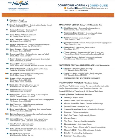
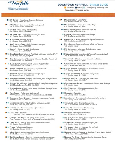
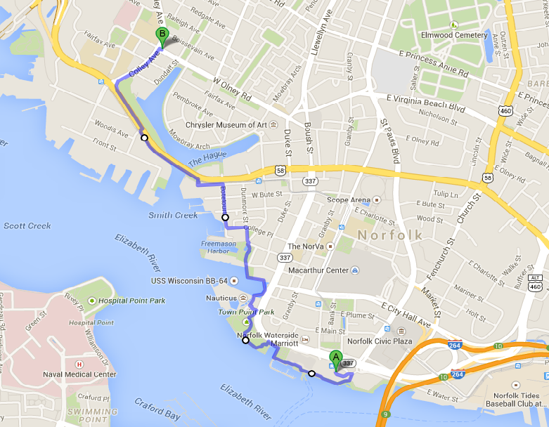
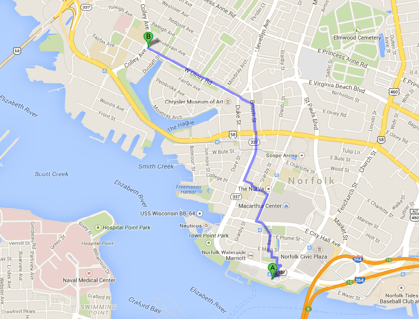
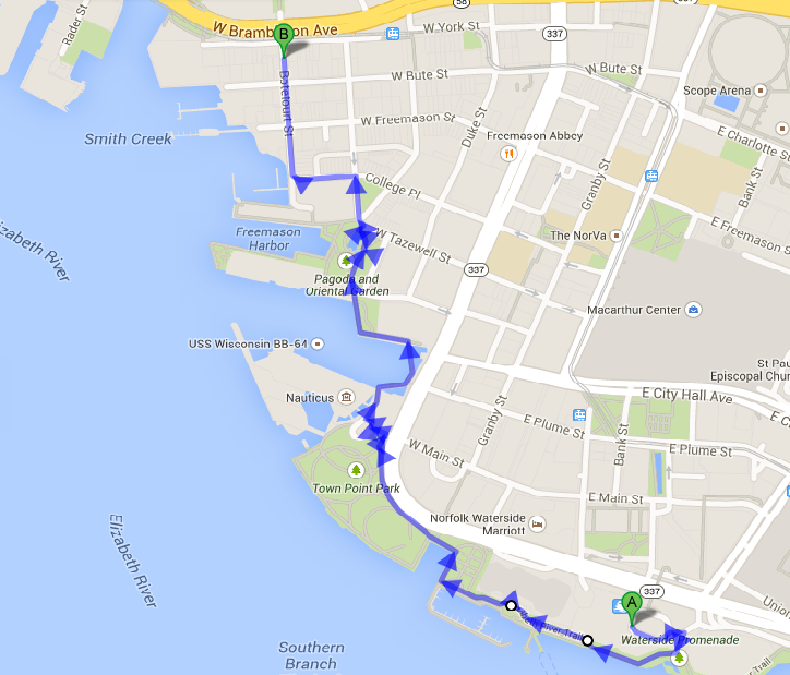
Local Transportation: Participants arriving by air at Norfolk International Airport have several options for ground transportation. The workshop venue is a short taxi ride from the airport (shortest connection is 7.6 miles, roughly 20 minutes and about $25.00). A rental car is only necessary (and recommended) if particants want to visit other locations besides the conference venue. WeatherWeather: The forecast for the period March 21 to 26, 2015 is indicating that there will be partly sunny weather with a chance of rain towards Thursday and Friday. Day temperatures will be somewhere in the 9 to 18oC range. See the most recent full forecast here. What to do and visit in Norfolk?Norfolk has many attractions resulting from 400 years of American history impacting the city. A good way of getting an overview is to walk along the “Cannonball Trail,” a self-guided tour through 400 years of Norfolk and American history. Ghent is a historic part of Norfolk. To get from the Sheraton to Ghent, riding the lightrail, called the Tide is a good alternative to walking through down-town (see the map below). Restaurants and BistrosThere are many options for lunch and dinner in walking distance from the Sheraton. The list below gives an overview. An interesting options is also to take the ferry that leave right outside the meeting venue to cross over to Portsmith, where you some nice option for dinner.
Norfolk also has several local breweries that are worth visting if you like beer. One of them is O'Connors Brewing Co. On Wednesday, March 25, 2015, “Wet Tails” is taking place there, which is a social event organized by Wetlands Watch, a local NGO addressing the challenge of sea level rise in the region. It might be an opportunity to mingle with people living in a region challenged by climate change and sea level rise and inceasingly being impacted by it. If you want to go, it is recommended to RSVP here. Another well know brewery is the Smarthmouth Brewing Co at 1309 Raleigh Ave, Norfolk, VA 23507 (Phone: (757) 624-3939). There, you also find a restaurant.
Workshop Dinner
ACCOMMODATIONThe workshop organizers had reserved a bulk of rooms at the conference venue for a group rate of $99.00 for a double room (plus tax) per night. To ensure group rates, reservations had to be made by March 1, 2015. After that date, there was still the possibility to get the group rates, depending on availability of rooms. |